Saturday, July 27, 2013

KATAHDIN!

It was hard to believe I was sitting at the base of the last mountain, with only 5 miles left on this incredible journey.

As expected, I slept about an hour that last night, and was excited to finally see 4am on my watch and eagerly started packing up. It was a cool crisp morning and good weather (the only good day in about a week) was promised.

Packed up very quickly and made my way down the day use parking lot and the start of the last section of the AT. Met my parents and Deanna there around 6:30 and by 6:45 we were on the trail!

The first mile or so is a nice gentle hiking trail with only a little elevation gain. It is perhaps the greatest false sense of security on the trail. It gives absolutely no hint to the 4 remaining miles.

The second mile definitely starts to give you more warning. You do some decent, though stepped climbing for a while, and then the rocks start. Normally I would call them boulders, but then I wouldn't have a descriptive word left for what miles 3 and 4 bring. You immediately start using your hands at every part and quickly abandon any need or use for trekking poles. Knee pads and gloves would be more useful to you. You continue like this for the better part of an hour...and only then do you even get above the tree line. Then the real fun (your definition dependent) starts.

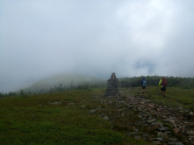
Miles 3 and 4 are pure rock climbing. The term "hiker" has long been abandoned. You quickly find yourself staring at boulders as big as cars in front of you, with nothing but more boulders, just as big, rising as far as you can see straight up in front of you. The only reason you can't see the end of them is because they are literally in the clouds. Some places have handrails and iron ladders built into the rock to help...others don't.

After a solid hour and 1/2 - 2 hours of this, depending on your speed, you reach "the table" and you're greeted with an absolutely ridiculous above-the-clouds view that let's you know you've done the bulk of the work. After that its a flat-ish mile rolling up to the grand summit.

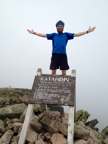
As we got closer, the clouds cleared a little and I got my first glimpse of the sign. Very very surreal feeling. Every northbound hiker ever, myself no exception, has thought long and hard about that sign and the moment of finishing...and here I was experiencing it first hand! The summit was far more crowded that I had imagined. It was the only nice day in a string of 6 or so, and a lot of people had taken advantage of it. Walking around people to reach the sign wasn't quite the finishing picture I had in my mind for so long, but at that moment, I didn't care at all. I just wanted the sign. I wanted the finish line. I wanted to conquer this thing!

I let Deanna go ahead while I took a minute to take in the full gravity of the moment. I looked around, took a big breath, and knocked down the last 50 yards of the AT!! 

Reached the sign just before noon on July 25th, marking 4 months and 14 days and the end to an absolute epic journey!! I enjoyed a celebratory beer with my buddy Hurricane at the top. Even though he already climbed it himself 3 days earlier, came to join me for a victory lap up the last mountain. It feels incredible, and at the same time bewildering and incomprehensible that a person could literally walk all that way. 

I can remember spending hours and hours thinking and planning this trip, and it's unbelievable to have my dream realized.

Thank you thank you again to all who helped make this possible! 

Also, working on an afterword to come....


Friday, July 26, 2013

The 100 Mile Wilderness

 Left Monson early on a Friday morning with rain storms threatening. The first part of the wilderness is known for large slabs of slate, which turn very slick when water is added to the mix. I was not looking forward to it at all, but I had a finishing deadline and hiker buddies to try and catch, so I was left with little choice but to keep walking.

"The Wilderness" is famous for being 100 continuous miles of no towns or paved roads in between...which means no help/resupply/etc. There's an ominous sign at each end warning of this as well as advising hikers to carry at least 10 days of food. With the way I eat, that would be a 50lb pack...no thanks. I was pretty sure I could knock it out in 4 or so.

Overall, I wish I could say better things about the wilderness, but it was probably the least enjoyable part of my trip. With the exception of White Cap Mountain, about 75 miles from the end, where you reach the summit and roll around the north side of the mountain and are rewarded with your first view of Katahdin, there was very little to see. Lots of swamps, ponds, bogs, mud, roots, and rocks. Oh yea and BUGS. The mosquitos were absolutely unbearable and single handedly ruined the wilderness. I would wake up in the morning and have 50 of them banging into the netting of my tent, just waiting for me to get out. It was depressing. That with the fact that the miles, even though I had 100 or less at the time, seemed to just last forever. But I had the end goal in sight and kept on moving.

Came out of the wilderness to Abol Bridge campground, right before the entrance to Baxter State Park, and only 9 miles from the base of Katahdin. Ran into some fellow thru hikers who were killing a day waiting on better weather. I was planning on killing a day anyways, so it was great to have company. Drank beer all day and watched it rain. 

As a thru hiker you are allowed to stay at The Birches (reserved for hikers who have done at least 100 continuous miles) right at Katahdin Stream Campground at the base of the mountain. The only catch is you can only stay one night, so you have to time it right to be there the day before you try and summit. Did the easy 9 miles to there on the 24th, with the intention of meeting Deanna and my parents the next day for the last 5 miles. The only problem is that you gain about 4,000 feet of elevation in 3.5 of those miles....


Thursday, July 18, 2013

Stratton ME to Monson ME

Last stop! 

Into Monson this morning for the last of everything. Last resupply, last shower, and last real food until the end. Nice little town. Stayed at the Lakeshore House, whose owner Rebecca is one of the nicest people you'll ever meet. Made me feel right at home. Within 5 minutes of being there I had a cold beer in my hand and food on the way. Spent some time eating, drinking, and relaxing by the lake. Nice to rest one last time before the last 100 miles.

The last few days have been really hard. Very rocky, rooty, boggy, and buggy. Have had some foot issues as well I've been dealing with. Haven't hiked by myself in a good while, and I found the miles very very slow. Very strange to not see another NOBO (north-bounder) for days on end. But slowly and surely I knocked down the miles.


On a more serious note:

I'm not sure if I will have cell reception/Internet from here on out so I wanted to take the opportunity to give some thanks out. Thank you, thank you to everyone who supported, believed, followed, and helped me along the way! I could not have done it without you. Really really really. In particular, I wanted to thank my mom for "letting go" and wishing me the best on this journey. Thank you to my dad for always believing in me, for trail-side support, and for being a great hiking partner. Thank you Melia for incredible baked goods support! And Chris and Kyle for hiking with me through some of the home stretch...hopefully we're still friends after the pain I put them through! Thank you to everyone else who sent me cards, notes, and inspirational messages along the way! And last, but of course not least, I want to thank Deanna, my ever-present rock star trail manager. From new shoes and socks, to food boxes, clothes, batteries, and everything else imaginable, she did it all. Thank you so much, this trip would have been far less easy if not impossible without you!

Onward onward...
109 miles to the base of Katahdin!!!


Sunday, July 14, 2013

Gorham, NH to Stratton, ME

Left the White Mountain Hostel in Gorham (which I highly highly recommend..one of, if not the best hostel on trail) and headed toward the last state line. Finally in Maine!

Very awesome to have Chris and Kyle come join me for a 50+ mile stretch. Definitely some hard hard terrain but they handled it like champs with smiles on their faces. I felt like a proud parent. 

Their first mile on the AT was Mahoosuc Notch, which is a mile long stretch of boulders at the bottom of a large gap. No hiking poles required, hands and arms are the tools of the trade. Nicknamed the "toughest mile" or "killer mile", we scrambled through it for over an hour. Several places have ice and snow in the bottom because the spot literally isn't ever reached by the sun. Awesome fun for sure, but the right attitude is a must...otherwise you're in for the longest mile ever.

Walked through a few days of rain but the sun finally came out! I felt like it had been several states since I really saw it. Finally got the boys some good vistas for their hard work. 

Came around the trail one day and found ourselves face to face with a moose. He stared at us for a minute and then took off running. Naturally I took off after him. I had come this far to see one and I wasn't missing the opportunity. Got an awesome video!

Left the boys and hauled it to Stratton ME for some last minute R&R before the big push to the finish. 

188 miles left on this journey! 


Saturday, July 6, 2013

Done with the Whites!

Made it through the whites and into Gorham! Exhausting tough terrain for sure, but very rewarding views, when you could actually see something and it wasnt fogged/clouded in. Mt Washington lived up to its hype and was a cold windy foggy place. Couldn't see the summit sign until I was about 5' away.

Less than 300 miles left! 


Tuesday, July 2, 2013

The Whites! (or at least 1/2 of them)

1/2 through the dreaded White Mountains! I have to say, they were not over-hyped in the least. Very very tough terrain. Constant 2-3k ascents and descents. 

Surprisingly though I enjoy the climbs more than the downs, which are very treacherous. My knees and legs have gained a few battle scars for sure. If I could use one word for the Whites it would be 'epic'. Incredibly raw, rugged terrain. You work very hard but are rewarded quite well. Incredible mountain top views with nothing but more huge mountains around you. The size and scale is unbelievable. My legs hurt more than they have the whole trail, and I've used my hands more in 3 days than in the previous 1800 miles. The walk along Franconia ridge above tree line is easily the most breath taking awesome place I've hiked thus far. 

Me and another hiker, Long-gone, did work for stay at Greenleaf Hut. All we had to do is talk to the 30 people staying there about being a thru hiker and answer questions for 30 minutes, and in return we got a dry place to sleep and all the food we could eat!

340 miles to go! Feels awesome to be in the home stretch. Hiker life is awesome and always interesting, but I'm definitely ready for some normal life complete with regular showers!